


![Collins London Pocket Map [Folded Map].jpg](/environment/cache/images/productGfx_ba9ea138d67813fef255bfce9c2b8853_0_0.webp "Collins London Pocket Map [Folded Map].jpg")
Collins London Pocket Map [Folded Map]
Kod produktu: COLLINS1
Deklarowana dostawa DO PUNKTU ODBIORU - do 48 godzin od DNIA WYSYŁKI w dni robocze. UWAGA - czas realizacji (wysyłki) zamówienia - od 5 do maksymalnie 12 dni
Koszty dostawy wybranego produktu
Cena dostawy dotyczy tego produktu (w wybranym wariancie - jeśli dotyczy). Może się ona zmienić po dodaniu innych produktów do koszyka.
Zapytaj o produkt

Administratorem danych osobowych jest British Shop in Warsaw (Fish and Chips Spółka z o.o.). Przetwarzamy je w celu przesłania odpowiedzi na zapytanie. Więcej informacji dotyczących przetwarzania danych osobowych znajduje się w polityce prywatności.
Udostępnianie karty produktu
Opis
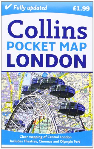
Handy little full colour map of central London with a high level of detail. Clear mapping of central London from Regent’s Park in the North to Kennington in the South and Kensington Gardens in the West to Tower Bridge in the East at a scale of 1:12,500 (5 inches to 1 mile). Inset maps of Olympic Park, West End shopping and theatres also included.
Clear, detailed, full colour mapping is presented in a handy format ideal for the pocket or handbag. It is excellent value at only £1.99 and covers the most visited area of central London.
INCLUDES
• Inset map of the new Olympic Park.
• Full central area map detail.
• Theatres and Cinemas map.
• Shopping Map.
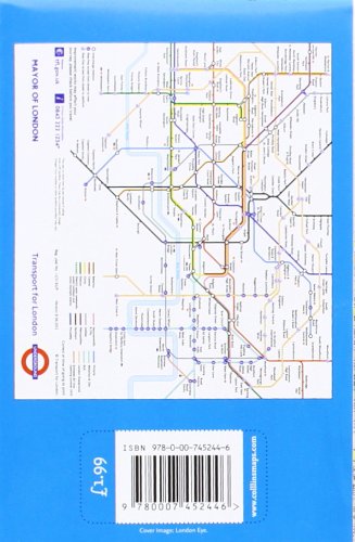
• Tube Map.
• The latest congestion zone boundary
Product Dimensions: 13 x 8.6 x 0.8 cm
AREA OF COVERAGE
Central London from Regent’s Park in the North to Kennington in the South and Kensington Gardens in the West to Tower Bridge in the East.
WHO THE PRODUCT IS OF INTEREST TO
Essential for the short term visitor or day tripper or anyone visiting London on a tight budget.
![Przejdź do produktu Collins London Pocket Map [Folded Map]](/environment/cache/images/productGfx_ba9ea138d67813fef255bfce9c2b8853_500_500.webp "Collins London Pocket Map [Folded Map].jpg")